The climate in Australia, and globally, has changed and is continuing to change at an increasing rate. The Bureau of Meteorology’s State of the Climate Report for 2020 indicated that over the past 50 years, there have been significant increases in average temperatures, increases in extreme heat events, a decline in average rainfall in southern Australia, a warming and acidification of the ocean, and rising sea levels. This has resulted in decreased river flows and an increase in extreme fire weather.
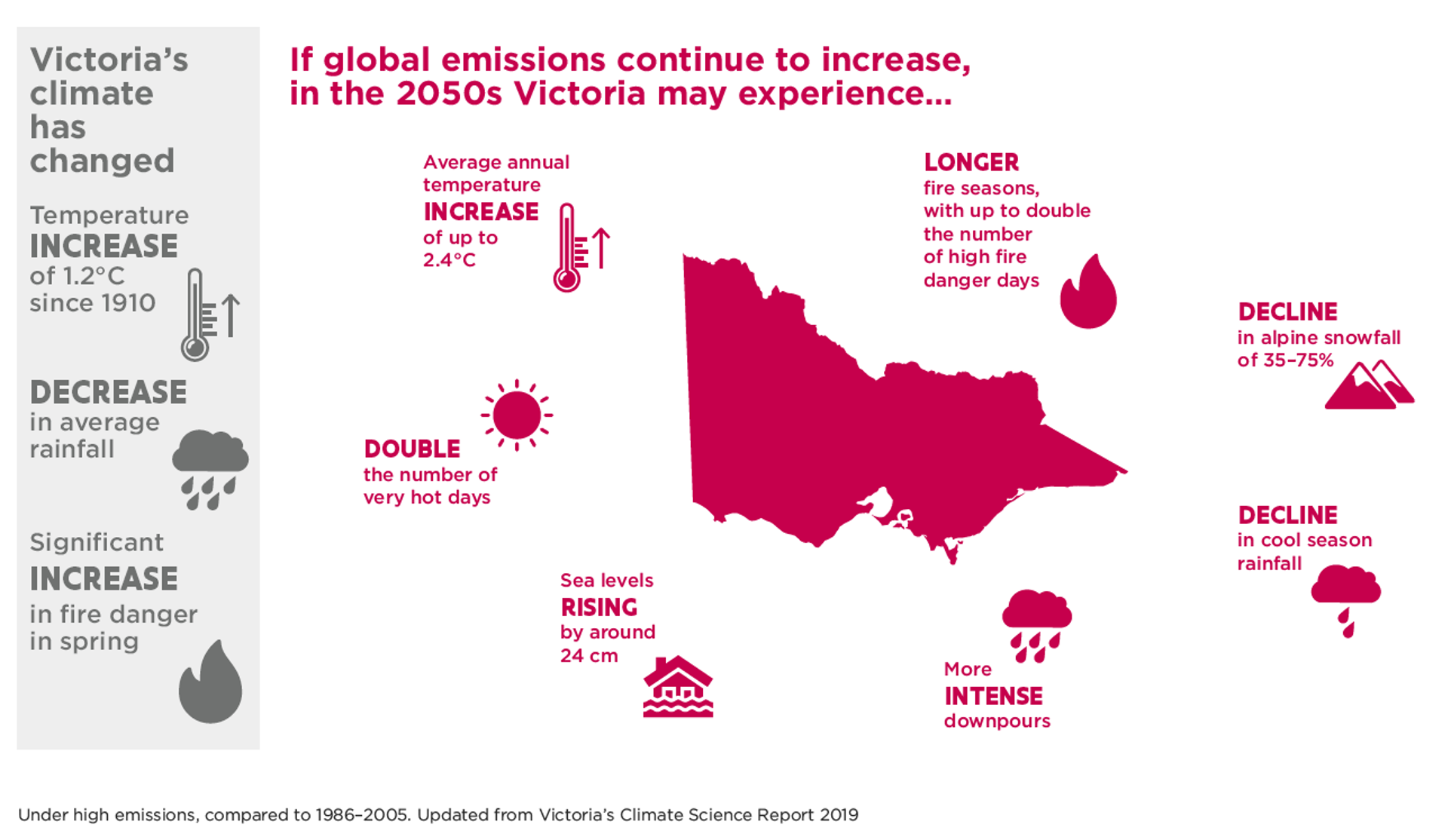
Projections of future climates are based on a number of modelling scenarios, which vary according to assumptions of future carbon dioxide emissions (Representative Concentration Pathways or RCPs). The most common model outputs are based in two scenarios (RCP 4.5) which assumes that there will be some reduction in global emissions and RCP8.5 which assumes continued high emissions. Under both these scenarios, the projections are for continuing trajectories of change with increased rates of change if emissions continue to increase (Figure 1).
Figure 1: Climate change projections for Victoria
Source: https://www.climatechange.vic.gov.au/victorias-changing-climate
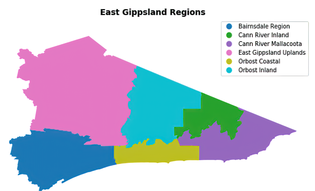
CSIRO have developed climate projections for six regions of East Gippsland (Figure 2). Projected change has been calculated relative to a 1986–2005 baseline. Under both predicted emissions scenarios, there will be continued warmer and drier conditions across the region.
Figure 2: Climate change regions of East Gippsland
Source: Victorian Climate Change Projections; Clarke et al. 2019.
Under the RCP8.5 scenario (which is currently considered to best reflect how global carbon dioxide emissions are tracking[1]) there is projected to be a 1.5–1.8 degree increase in average daily temperature by 2050 and a 3–4 degree increase by 2090. This means that by 2070 temperatures in the Alpine Peaks will be more like those historically experienced in Bairnsdale (Figure 3). In addition, both modelled scenarios project a dramatic increase in the number of days per year with temperatures greater than 35°C (Table 1). There will also be a halving of the days with minimum temperatures of less than 0°C. This will be pronounced for the Alpine Peaks local area, where this number is projected to fall from over 45 days to 26–28 days per year.
Figure 3: Median projected increases in annual temperature for RCP8.5
Source: Victorian Climate Change Projections; Clarke et al. 2019.
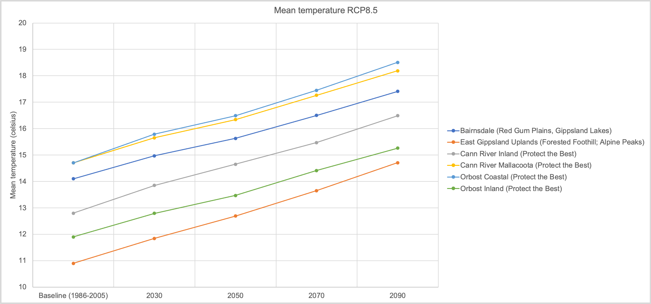
Table 1: Days per year with maximum temperatures greater than 35°C.
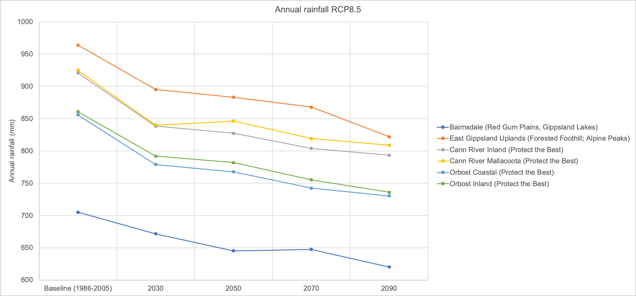
Rainfall is also projected to decline across all the local areas in East Gippsland (Figure 4). The traditionally high rainfall alpine areas will have rainfalls closer to that historically experienced in the coast. There will also be a shift in the seasonality of rainfall, with minor increases in summer rainfall, but dramatic declines in winter and spring rain.
Figure 4: Median projected decreases in annual rainfall for RCP8.5
Source: Victorian Climate Change Projections; Clarke et al. 2019.
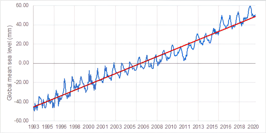
A combination of factors are contributing to sea level rise. This includes thermal expansion of the ocean as temperatures increase as well as inflows of water as glaciers and ice sheets melt. Accurate measures of sea level from satellite extend back to 1992, and this indicates that sea levels are rising at a rate of around 3.5 mm per year (Figure 5). In terms of future projections, it is estimated that the seas around the Gippsland Coast will rise by 18 to 35 centimetres by 2050 (https://coastadapt.com.au/sea-level-rise-information-all-australian-coastal-councils#VIC_EAST_GIPPSLAND). It should be noted that these levels may be higher, depending on the trajectory of Antarctic ice sheet melting in the future.
Figure 5: Mean global sea level since 1992 with seasonal signal (blue) and trend line (red).
Source: https://www.cmar.csiro.au/sealevel/sl_hist_last_decades.html
[1] Schwalm, C.R., Glendon, S., and Duffy, P.B. (2020). RCP8.5 tracks cumulative CO2 emissions. Proceedings of the National Academy of Sciences 117(33): 19656.
Water
Increased temperatures and decreased rainfall will result in a decrease in surface water and river flows. Rivers in East Gippsland have already experienced a decline in surface water availability of between 10 and 14% (1997 to 2018 compared to the long-term historical average[1]) and will continue to decline under future climatic conditions. This has implications for plants and animals that rely on freshwater aquatic habitats, with a decrease in wetland area and an increase in the area and extent of dry periods in rivers and wetlands. A loss of connectivity between rivers, wetlands and the sea will impact on native fish, many of which rely on migration to complete their lifecycles. Decreased durations of inundation in wetlands will impact on waterbirds, frogs and invertebrates and may result in reduced populations if wet periods are too short for breeding cycles to be complete. Water quality in riverine pools and drying wetlands will decline as salts and nutrients concentrate in smaller pools of water. This can lead to conditions that are beyond the tolerance of fish and other aquatic biota and increase the severity of algal blooms. There will also be effects on consumptive use, with decreases in water availability occurring at the same time that there is increased demand for domestic and agricultural water supplies during hotter and drier periods. Impacts to agriculture from decreases of water over time include, soil moisture changes, and water quality impacts and risk of increases in blue green algae blooms to livestock.
[1] Department of Environment, Land, Water and Planning 2020, Long-Term Water Resource Assessment for Southern Victoria, State of Victoria, Melbourne.
Coasts and marine
Decreased freshwater inflows and rising sea levels will impact the Gippsland Lakes, with increasing salinity across the system becoming more common. Hotter conditions will also result in increased frequency and duration of algal blooms in the Lakes. Rising sea levels also impacts saltmarsh and fringing vegetation subjecting these vegetation communities to deeper water. This will be a particular problem in areas where there are barriers such as roads and other hard infrastructure preventing landward migration of saltmarsh and paperbark communities.
Reduced freshwater inflows will also affect estuary openings, with more prolonged periods of closed conditions. This impacts on the quality of habitat in the estuary and prevents migratory fish from moving between rivers and the sea to complete breeding cycles.
Rising sea levels and increased storm surges will increase erosion pressures on shorelines impacting natural environments and built infrastructure such as boat moorings and jetties. While ocean acidification will have impacts to marine biota and reefs, particularly to animals with calcium shells such as molluscs.
Biodiversity
Increased hot and dry conditions will mean an increase in the frequency and severity of bushfires. If fires occur more frequently than habitats and animal populations can recover, then long term impacts to population viability can be expected. Alpine areas are highly vulnerable to climate change impacts with reduced snowfall and an increase in the altitude of snow fall. Plants that require periods of chilling to complete lifecycles may not survive.
Many of the impacts to flora and fauna are difficult to predict exactly, and the adaptive capacity of many species and ecological communities are also not well understood. It is expected that gradual changes in temperature and rainfall may see changes in the composition of vegetation communities as more resilient species cope in a warmer and drier climate. There is potential that transformational change may occur in some ecological communities, even with only minor changes to climate. There may be an increase in pest plants and animals that are more adaptable to changing conditions, and of native species more resilient to a warmer and drier climate. Fauna species may experience changes in behaviour, abundance and distribution as well as potential shifts in regular cycles such as migration or breeding.
Land
A hotter and drier climate with reduced water availability will put significant pressure on the agricultural sector. As conditions change, historical farming practices and products may no longer be viable in some areas. Livestock are vulnerable to changes in temperature and water availability and an increase in the number of hot days. Dairy cattle are particularly affected by heatwaves with a reduction in milk productions and an increase in illness and even death. Increased drought and bushfire risk will also affect forestry in East Gippsland with reduced growing rates and prolonged recovery periods.
Community
Climate change will impact on Traditional Owners’ tangible and intangible cultural heritage. Impacts will include changes on Country to plants and wildlife, reduced stream flows, coastal impacts on cultural heritage sites of significance through inundation and erosion as well as significant and severe events such as fires and flooding.
The increased reach of climate change influences on the community will be driven by the projected impacts on health and wellbeing, the economy, and lifestyles. The combination of gradual climactic changes and extreme events will create both direct (e.g. heat stress, negative mental health impacts) and indirect (e.g. air pollution from bushfires) impacts on human health. Impacts to agriculture can have financial impacts to members of those communities, which will extend to regions that support them. Increased bushfires and extreme events will impact on transport and the built environment, putting further strain on communities that may become increasingly isolated.
Victoria is taking a systems approach to climate change adaptation establishing strategies and implementing action plans at State, regional and sub-regional scales (Figure 6). The Victorian Climate Change Strategy (2021–26) sets adaptation objectives for the next decade and priorities for the next five years. Under this strategy, there are seven Adaption Action Plans (AAPs), three of which are of direct relevance to the East Gippsland RCS: Natural Environment, Primary Production and Water Cycle systems. Complementing the AAPs are six regional adaptation strategies. The Gippsland Regional Climate Change Adaptation Strategy (2021 to 2026) is a five-year plan that aims to strengthen resilience to climate change by building adaptive capacity and supporting the delivery of targeted adaptation action in Gippsland. At the local scale, the East Gippsland Climate Change Adaptation and Mitigation Plan identifies the impacts and opportunities from climate change for the local areas of East Gippsland.
Figure 6: Victoria’s Climate Change Strategy 2021-2026
Victoria’s Climate Change Strategy 2021-2026
A pathway to achieve net-zero emissions by 2050 and build resilience to the impacts of climate change.
Natural Environment Adaptation Action Plan 2021-26
Water Cycle Adaptation Action Plan 2021-26
Primary Production Adaptation Action Plan 2021-26 and the Agriculture Sector Pledge
Gippsland Regional Climate Change Adaptation Strategy 2021-26
Over 100 adaptation actions that are either being implemented or have been identified for future implementation in Gippsland:
East Gippsland Climate Change Adaptation and Mitigation Plan
Strategic Adaptation Options for highly vulnerable assets (Gippsland Lakes and fringing wetlands; Lake Tyers Alpine peatlands and Red Gum Plain wetlands); plus three areas of focus:
What’s being done?
The East Gippsland Climate Change Adaptation and Mitigation Plan identifies Strategic Adaptation Options for highly vulnerable assets and focal areas in East Gippsland. Some examples of how these are being implemented across the region are provided in Table 2.
Table 2: Climate change adaptation initiatives in East Gippsland.