Overview
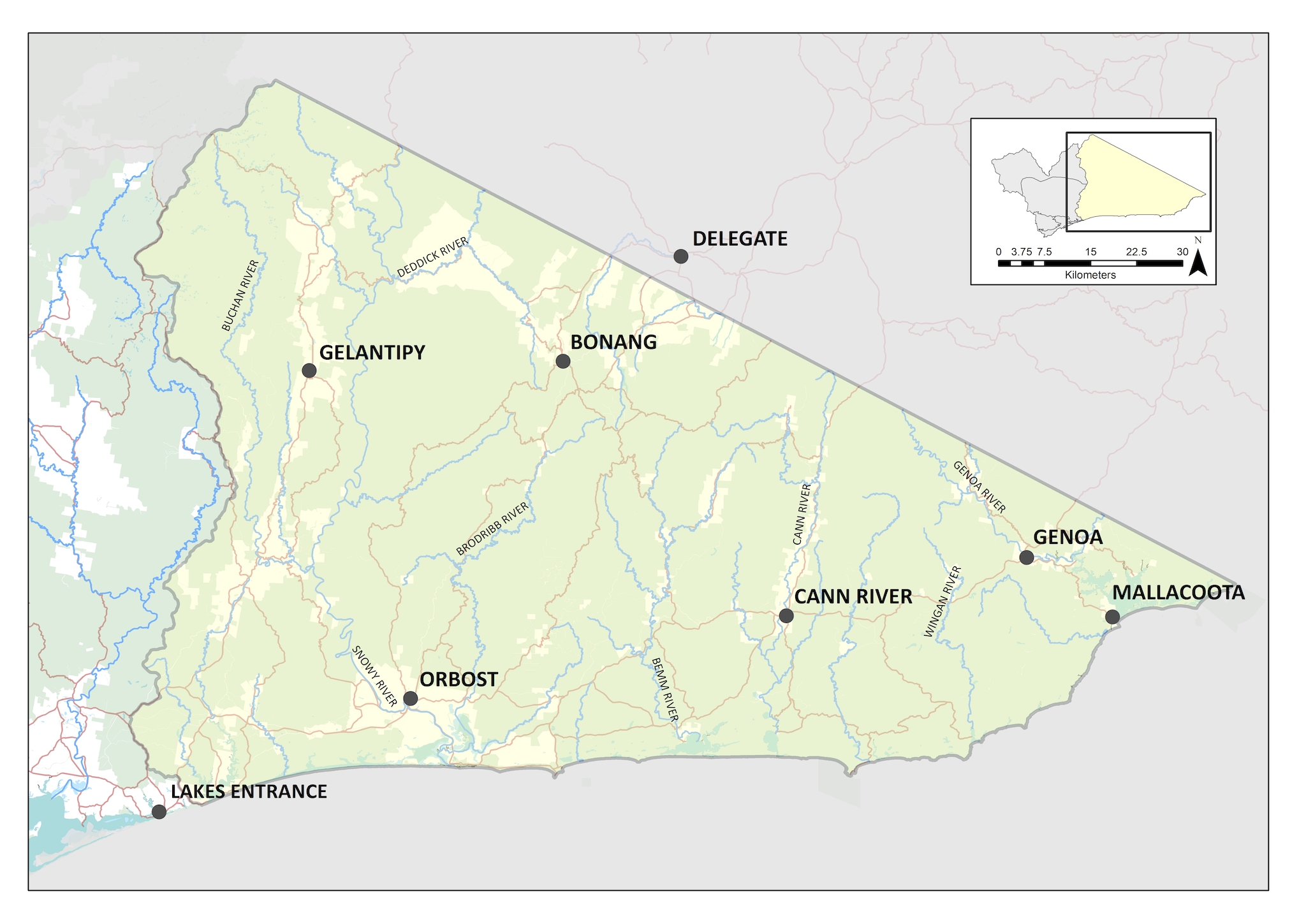
The Protecting the Best – Far East Gippsland Local Area is focused on maintaining the condition of the relatively undisturbed landscape in East Gippsland. It features large tracts of continuous native vegetation communities and ecosystems of high quality, particularly rivers and streams. The majority of the area is public land, including the internationally listed UNESCO Croajingolong Biosphere Reserve, and other significant areas such as the Croajingolong, Coopracambra, Errinundra, Snowy River and Alpine National Parks.
Several areas of cleared land punctuate the landscape. These areas are used mostly for agricultural production. Most are located in river valleys such as Orbost, Cann and Genoa rivers. Isolated cleared areas in the uplands including Gelantipy and Amboyne are mostly used for grazing.
Five waterways are recognised as Victorian ‘heritage rivers’, with the Snowy and Bemm rivers being recognised in their entirety. High value streams are a feature of the area, with many waterways having largely unmodified catchments. A number of streams cross the Victoria–New South Wales border, with the Snowy and Genoa rivers having the majority of their catchments in New South Wales.
This local area includes a long stretch of coastline with numerous estuaries and unique marine values. There are three significant marine protected areas: Point Hicks Marine National Park, Cape Howe Marine National Park and Beware Reef Marine Sanctuary, which support significant marine biodiversity.
Available data indicate that the Protecting the Best- Far East Gippsland Local Area is in very good condition (Table 1). In 2019−20, however, bushfires affected over 80% of this local area, burning a large proportion of the native vegetation and killing or displacing large numbers of animals. The full extent of the impact and recovery from this event is not yet fully understood. A range of bushfire recovery programs have been implemented following the the fires experienced in this Local Area.
Table 1: Condition and trend of Protecting the Best – Far East Gippsland Local Area
The high proportion of public land and retention of much of the native vegetation and habitats of the region, coupled with a relatively sparse population, means that the Protecting the Best- Far East Gippsland Local Area is subject to lower levels of threat from changed land use than elsewhere in Victoria and the East Gippsland Region. Over much of the local area threats to biodiversity arise from:
Climate change
Increase in temperatures coupled with decreased rainfall have led to an increase in the risk of severe bushfire events. This occurred in 2019-20, where extensive areas of of native vegetation was destroyed by extensive bushfires, resulting in direct death of flora and fauna and loss and alteration of habitat. Over one million hectares, (56% of the East Gippsland region) was burnt.
Pest plants and animals
Despite retaining a high cover of native vegetation, East Gippsland is a high priority area for pest & weed control due to its significant biodiversity value. Horses remain a significant threat in alpine areas. Damage to vegetation communities (including threatened communities and species) is a common impact through overgrazing and bark chewing in medium to high-density horse areas and trampling leads to erosion and water quality impacts to fragile ecosystems such as wetlands and peatlands. Pigs are a significant threat being managed in the Upper Snowy and Snowy River corridor to prevent further incursions from NSW populations into more vulnerable areas to the south. Deer are a significant threat across all landscapes in the region causing damage to vegetation communities, threatened flora species and resulting in loss and degradation of habitat for native fauna. Introduced predators such as foxes and cats remain a threat to wildlife including birds, frogs, reptiles and native mammals. In the marine parks, urchin barrens, caused by an increase in invasive, native species are having an impact on biodiversity values and visitor amenity.
Vision
The unique and connected landscapes of the Protecting the Best – Far East Gippsland Local Area with its extraordinary diversity of plants and animals, rare alpine ecosystems, vast forested environments, and wild coastal places are valued and protected. The outstanding values of the marine environments and the diversity of plants and animals of the area are enjoyed and respected by the supported and resilient communities of the area.
By 2040, the long-term objectives for the Protecting the Best – Far East Gippsland Local Area area are to:
- implement integrated programs of work to maintain or improve the condition of the high value alpine, forest and coastal environments of Far East Gippsland through ongoing cooperation and coordination between agencies and organisations
- maintaining the health of waterways in Far East Gippsland, particularly heritage and other priority rivers
- monitor and manage invasive species, including early detection and response where required.
- promoting awareness of, and participation by, communities in the management of invasive plants; and animals.
This will be achieved by focussing on the following themes:
- Coasts and marine – managing estuary openings and protecting the biodiversity of marine national parks
- Water – protecting and restoring waterways and riparian zones
- Biodiversity – working with land managers across the region to address established and emerging invasive species and a focus on recovery from and resilience to bushfires
- Land – reducing erosion following bushfires and supporting communities to implement best practice soil management, including maintaining appropriate ground cover across agricultural land
- Community – partnering with Traditional Owners to maintain the health of Far East Gippsland’s landscapes and supporting community groups to become involved in natural resource management.
Outcomes
Coasts and Marine – managing estuary openings
Current State
(2021)
Ideally estuaries are allowed to open and close naturally. There are times, however, when flooding impacts would cause long term impacts to adjoining land and infrastructure and active estuary management is required.
Medium-term
Outcomes (2027)
The artificial entrance openings in the local area have been completed in line with a regionally agreed approach that appropriately considers environmental, cultural, economic and social outcomes.
The condition of Lake Tyers, Sydenham Inlet and Mallacoota Inlet is maintained as good or better, and improvement is observed in the influence of river flows on the Snowy River Estuary entrance
Long-term
Outcomes (2040)
Tthe overall condition of estuaries is good or better for 90% of estuaries in the local area.
Coasts and Marine – protecting biodiversity in marine national parks
Current State
(2021)
There are three marine parks within this local area (Point Hicks Marine National Park, Cape Howe Marine National Park and Beware Reef Marine Sanctuary). The biodiversity values at each of these parks is high and they attract many tourists to the region. Sea urchins are native marine animals, but under certain circumstances, they can experience a population growth resulting in urchin barrens that are devoid of macroalgae. Control programs at Beware Reef Marine Sanctuary have managed the invasive species, but similar works are required at Cape Howe and Point Hicks.
Medium-term
Outcomes (2027)
Sustainable sea urchin populations are maintained in all three marine parks.
Long-term
Outcomes (2040)
Understory species (kelp and other marine macroalgae) have been restored and sea urchin barrens are no longer visible features of the marine parks.
Water – protecting and restoring waterways and riparian zones
Current State
(2021)
Domestic stock impacts on riparian corridors may be low compared to other locations in the State, but have been identified as a risk in some locations (e.g. Brodribb-Bemm Foothills, Genoa, Buchan and Lower Snowy). In addition, the Snowy River has over 90% of the natural flows extracted, resulting in impacts to river processes and biota.
Medium-term
Outcomes (2027)
Species control on rivers leads to reduced cover of willow, with priority rivers maintained as free of willows.
Livestock are excluded from grazing on 75% of waterway frontages in cleared sections of priority reaches.
Extent, structure and diversity of vegetation on riparian corridors improved within cleared sections of selected priority reaches leading to improvements in in-stream habitat and bank stability.
Improved understanding of the risks to the condition of priority waterways.
Long-term
Outcomes (2040)
The condition of riparian vegetation is improved in priority cleared waterways, providing habitat for native animals, and improving resistance and resilience, reducing risk of instability (Snowy River and rivers of the far east).
The condition of forested priority waterways and remote coastal wetlands is maintained.
Water – protecting and maintaining native fish populations
Current State
(2021)
Although the waterways of the local area are largely in good condition and barriers to connectivity are low, brown trout have been identified as a potential threat in some headwater streams and the effects of recent bushfires on water quality and habitat is of concern. The risk is highest in streams that support threatened galaxias species including McDowall’s galaxias, East Gippsland galaxias and Cann galaxias.
Medium-term
Outcomes (2027)
Suitable habitat is maintained in priority locations for small threatened native fish species by 2027.
Long-term
Outcomes (2040)
Populations of the following small native threatened fish species are stable: McDowall’s galaxias, East Gippsland galaxias and Cann galaxias.
Fish populations can move freely within the river systems of far East Gippsland critical times of year.
Biodiversity – work with land managers across the region to address established and emerging invasive species
Current State
(2021)
Invasive plant and animal management in the Protecting the Best – Far East Gippsland area is currently focused on the profile of high value areas (e.g. the Southern Ark project area and heritage and other priority rivers). It is effective in those areas where there is consistent effort, but the approaches could be better coordinated across the region.
Medium-term
Outcomes (2027)
Integrated large herbivore control (deer, horses, pigs) is implemented in priority locations to protect and maintain important biodiversity values.
Predator (fox and cat) control is completed in priority refuge habitats.
Control of transforming weeds in priority vegetation types and high value waterways, supported by the Far East Eden Strategy and priorities identified in the Biodiversity Response Planning process.
Long-term
Outcomes (2040)
Populations of threatened species and ecological communities are maintained.
Biodiversity – recovery from and resilience to bushfires
Current State
(2021)
The 2019/20 bushfires impacted a large proportion of the Protecting the Best – Far East Gippsland Local Area. The full extent of the impact of past fires is not yet understood and recovery trajectories remain unknown. Climate change projections are for increased severity and frequency of fires and resilient landscapes are crucial to the survival of the unique biodiversity of this local area.
Medium-term
Outcomes (2027)
Actions to address threats acting on priority unburnt habitat are implemented to maintain key values are protected and maintained.
Regeneration in littoral rainforest and coastal vine thicket communities has progressed, including the management of deer to assist in recovery
Monitoring and reconnaissance of priority species and habitats in fire affected areas is complete.
Long-term
Outcomes (2040)
The recovery trajectory of East Gippsland forests is well understood and being observed across the local area.
There will be no loss of threatened species from the local area.
Land – reducing erosion following bushfires
Current State
(2021)
The 2019/20 bushfires impacted a large proportion of the Protecting the Best – Far East Gippsland Local Area. While much of the land affected was public and supported natural values, there were impacts to productive agricultural lands as well particularly in the Snowy and Buchan Valleys.
Medium-term
Outcomes (2027)
Best practice soil management, including maintaining appropriate ground cover is implemented at 60 % of priority sites across the agricultural landscape.
Long-term
Outcomes (2040)
Targeted improvement of the productive values and stability of the Snowy Mountain Basin and Buchan Valley agricultural land and soils.
Community – partnering with Traditional Owners to maintain the health of East Gippsland’s landscapes
Current State
(2021)
The relationships with Aboriginal groups are developing and there have been examples where government agencies have worked with Moogji Aboriginal Council to deliver on-ground works
Medium-term
Outcomes (2027)
Constructive working relationships are built between all Traditional Owner groups within the local area with land and waterway managers and community groups.
Mechanisms are in place supporting the involvement of Traditional owners in natural resource management across the local area, including the incorporation of traditional ecological knowledge into management practice.
Long-term
Outcomes (2040)
There are many sites across East Gippsland where the Traditional Owners work in close partnership with government agencies, jointly planning and managing invasive pests at these locations. This protects both the cultural and natural heritage of the area.
With respect to the delivery of actions outlined in each of the Local Areas covered by this RCS, there are four phases in the implementation framework:
- Target setting – A vision is set for each local area, including outcomes, aiming for the healthiest environment tailored to community and Traditional Owner aspirations and regional characteristics. Actions are developed in collaboration with partner agencies, targeting threats to the Local Area.
- Taking action – Land managers and community work intensively to maintain and improve our natural environments. Examples of work undertaken during this phase include pest plant and animal control, revegetation, and hosting engagement events. This phase is working together to achieve results on the ground.
- Recovery and growth – Once the delivery of on ground works is complete, the local area (and the life within it) will take some time to recover and establish. In some cases, environmental works will cause a minor decline before the environment can find its balance and improve in condition. This phase provides for on ground works to be delivered at a level for the environment to establish into a stronger, more resilient, and healthier Local Area.
- Target achieved – The Local Area is resilient, providing community values and is largely naturally sustained. Threats to the local area are now reduced (along with the costs to fix them). The environment is stronger, more resistant, and resilient to threats. The local area will need minimal maintenance, although ongoing monitoring may be required, and the outcomes have been achieved
These phases describe the current status and trajectory of the local area. Different places across a single Local Area may be in different phases of the implementation framework. Although work has been occurring in far East Gippsland for some time, it has largely focussed on two areas – protecting heritage rivers and protecting native mammals from predators (especially foxes). There has been some local level coordination and communication, but an overall approach or plan is still needed for the area. Whilst much of the Protecting the Best – Far East Gippsland Local Area is in Phases 3 and 4, the project still requires a planning or Target Setting phase to coordinate ongoing protection and bring all areas into the maintenance phase.