The ‘water theme’ of this Regional Catchment Strategy includes the rivers, wetlands, water resources, and groundwater of East Gippsland, including the aquatic biodiversity supported by these freshwater systems. Our region is one of the few places on mainland Australia where continuity of natural ecosystems from the alps to the sea still exists.
Our water dependant values… a snapshot
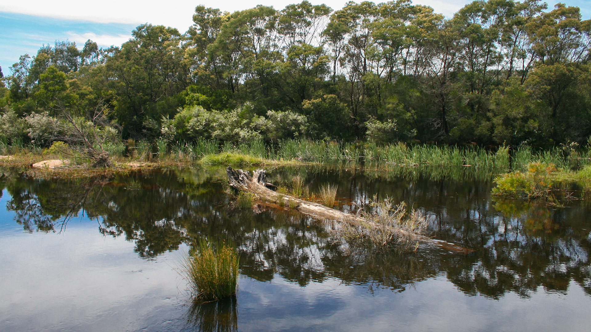
The waterways of East Gippsland support significant ecological, social and cultural values. Fresh water is critical to the productivity of the region and our aquatic habitats support a large number of threatened species that depend on these ecosystems.
The rivers of East Gippsland rise in the Great Dividing Range, and flow generally south to discharge into Bass Strait. Rivers in the east flow through smaller estuaries and inlets to discharge directly to the sea, whilst the Mitchell and Tambo Rivers discharge to the Gippsland Lakes, before water flows to the sea through Lakes Entrance.
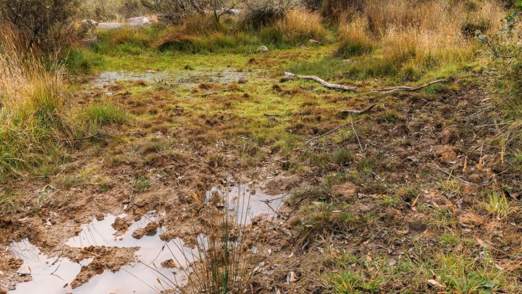
Wetlands within the region occur in alpine areas, along the coast (see coastal theme), and there are a small number of floodplain wetlands, including Macleod Morass, which is part of the Gippsland Lakes Ramsar Site.
Fertile lower floodplains, including the Mitchell River in particular, are utilised for agriculture including irrigated horticulture operations.
The waterways of East Gippsland are valued by the local community, visitors to the region and the broader Australian community.
The waterways of East Gippsland support significant ecological values including a large number of threatened species with 350 species of plant, 44 species of bird, 11 species of frog, 9 species of fish and 1 mammal species that are dependent on these aquatic ecosystems.
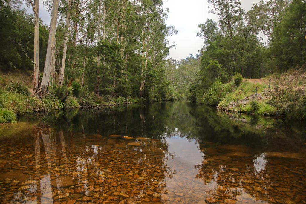
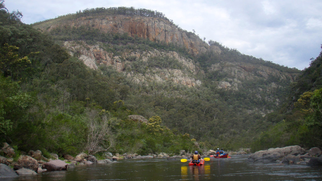
The major rivers of the region are largely unregulated with the only major storage in the region located on the Nicholson River, although there is a major storage on the Snowy River upstream of East Gippsland in NSW. As a result, most of the river systems have low modifications to the flow regime and support significant natural values. East Gippsland contains several rivers which have no barriers to fish passage, including the Benedore, Thurra, Suggan Buggan and Berrima Rivers, all of which are listed on the Directory of Important Wetlands in Australia. These river systems also have few or no introduced fish species, which when coupled with connectivity from headwaters to the sea, results in a high diversity and abundance of native fish. Many of the rivers of East Gippsland support the nationally endangered Australian grayling as well as a diversity of riparian and aquatic plants. The pristine nature of many of the rivers in East Gippsland enhances their ecological values and provides unique habitat for a variety of species. For example, the Wongungarra River contains the only unmodified habitat for the endangered spotted tree frog.
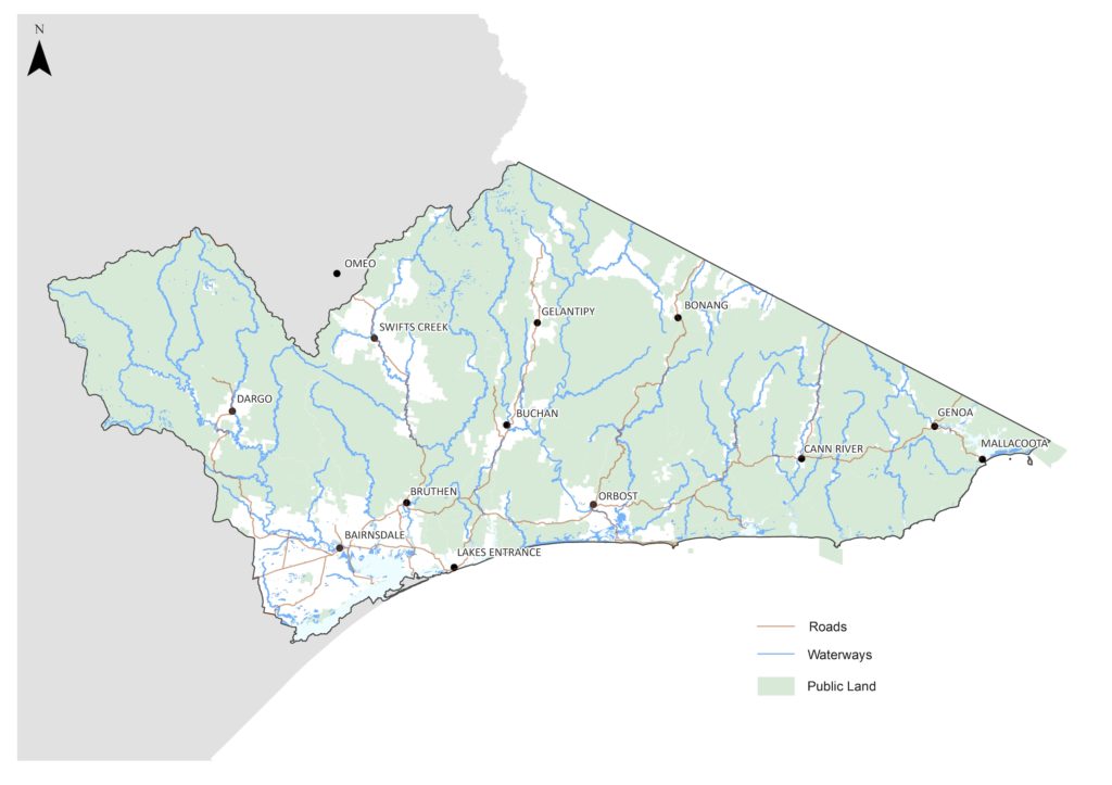
Figure 1: Waterways of East Gippsland
The peatlands of the alpine region of East Gippsland are rare in Australia. These are permanently wet sites that contain at least one species of Sphagnum in areas above 1000 metres in elevation. They perform important functions, filtering nutrients and sediments, and maintaining good water quality in streams and groundwater. They support a diversity of aquatic flora and fauna including threatened species like alpine pennywort, alpine bog skink, alpine water skink, and alpine spiny crayfish, as well as the nationally vulnerable alpine tree frog. Significant alpine wetlands in East Gippsland include the nationally important Nuniong Plateau Peatlands and the threatened ecological community ‘Montane Swamp Complex’, which comprises seven small sites (total of 44 hectares) on the tributaries of the western headwaters of the Tambo River.
The waterways of East Gippsland support 27 different ecological vegetation communities (EVCs) that are considered river or wetland dependent. Combined these cover an area of almost half a million hectares and include areas of alpine bog, extensive riparian forests and woodlands and large areas of wet or damp forest (Table 1).
Table 1: Waterway dependent ecological vegetation classes in East Gippsland
The waterways of East Gippsland are valued by the local community, visitors to the region, and the broader Australian community. The health of these waterways underpins many aspects of regional tourism, jobs and investment, particularly in coastal areas such as the Gippsland Lakes. Fishing, swimming, camping and boating are all popular in East Gippsland.
Although water extraction for consumptive use is low in East Gippsland, compared to many other regions in Victoria, there are licensed extractions from the river systems. This includes for industrial and agricultural use (e.g. irrigation from the Lower Mitchell) as well as for stock and domestic purposes.
Groundwater extraction in East Gippsland is generally low and the only groundwater management area is Orbost. There is also extraction of groundwater outside of the management units, with Lindenow and Mallacoota urban water supply and the agricultural areas along the Mitchell floodplain extracting water for consumptive use. Groundwater is also extracted in areas across the Redgum Plains to the east of Bairnsdale to support irrigated agriculture.
Despite the pristine nature of much of East Gippsland, waterways of the region are still subject to threatening processes. This includes the impacts of pest plants and animals, climate change and associated hotter and drier conditions directly impacting water regimes, as well as increasing risks from bushfires.
Increased temperatures and decreased rainfall will result in a decrease in surface water and river flows. Rivers in East Gippsland have already experienced a decline in surface water availability of between 10 and 14 % (1997 to 2018 compared to the long-term historical average[1]) and will continue to decline under future climatic conditions. This has implications for plants and animals that rely on freshwater aquatic habitats, with a decrease in wetland area and an increase in the area and extent of dry periods in rivers and wetlands. A loss of connectivity between rivers, wetlands and the sea will impact on native fish, many of which rely on migration to complete their lifecycles. Decreased durations of inundation in wetlands will impact on waterbirds, frogs and invertebrates and may result in reduced populations if wet periods are too short for breeding cycles to be complete. Water quality in riverine pools and drying wetlands will decline as salts and nutrients concentrate in smaller pools of water. This can lead to conditions that are beyond the tolerance of fish and other aquatic biota and increase the severity of algal blooms. There will also be effects on consumptive use, with decreases in water availability occurring at the same time that there is increased demand for domestic and agricultural water supplies during hotter and drier periods.
In the forested uplands of the region, one of the major threats to waterway values are invasive plants and animals. Alpine peatlands and upland pristine streams are at extreme risk from deer and feral horses, with hard hooves causing significant and often irreversible damage to fragile peat communities. Willows and non-woody weeds also pose a threat to these communities, with invasion of willows following bushfire of particular concern. Climate change (hotter and drier conditions) can have major impacts to alpine peatlands and the associated increase risks from bushfires are significant. Alpine peatlands are highly vulnerable to fire and need to be protected from fuel reduction burning and associated traffic and machinery.
In the Snowy River, altered flow regimes have significant effects on waterway health. Almost 90% of the flow from the Snowy River is extracted upstream of East Gippsland and the reduction in flows has resulted in changes to the river channel and alterations to the ecology of the river system.
On the lower reaches of rivers, where there are more settlements and agricultural activity, clearing of riparian land and loss of native habitat is considered a significant threat. Stock access to waterways increases erosion and decreases water quality and impacts on riparian vegetation in lowland river reaches. Disturbance of vegetation and waterways allows the establishment of invasive plant species in these environments. Feral pigs, goats, and deer all pose a threat to waterway values and increased introduced predators such as foxes and cats impact the animals that are dependent on the aquatic environment for habitat.
[1] Department of Environment, Land, Water and Planning 2020, Long-Term Water Resource Assessment for Southern Victoria, State of Victoria, Melbourne.
Wetlands
There is limited information on the condition of wetlands in the East Gippsland region. Index of Wetland Assessments completed in 2009 and 2010, cover a small number of floodplain and alpine wetlands and indicate that while the alpine wetlands are largely in good or excellent condition, the floodplain wetlands are generally in moderate condition overall (Table 2). The pristine catchment conditions and largely unmodified hydrology in alpine wetlands maintain good ecological condition, while higher catchment pressures and altered hydrology are affecting the small number of wetlands assessed in lowlands.
Table 2: Index of Wetland Condition assessments for wetlands in East Gippsland (2009 and 2010).
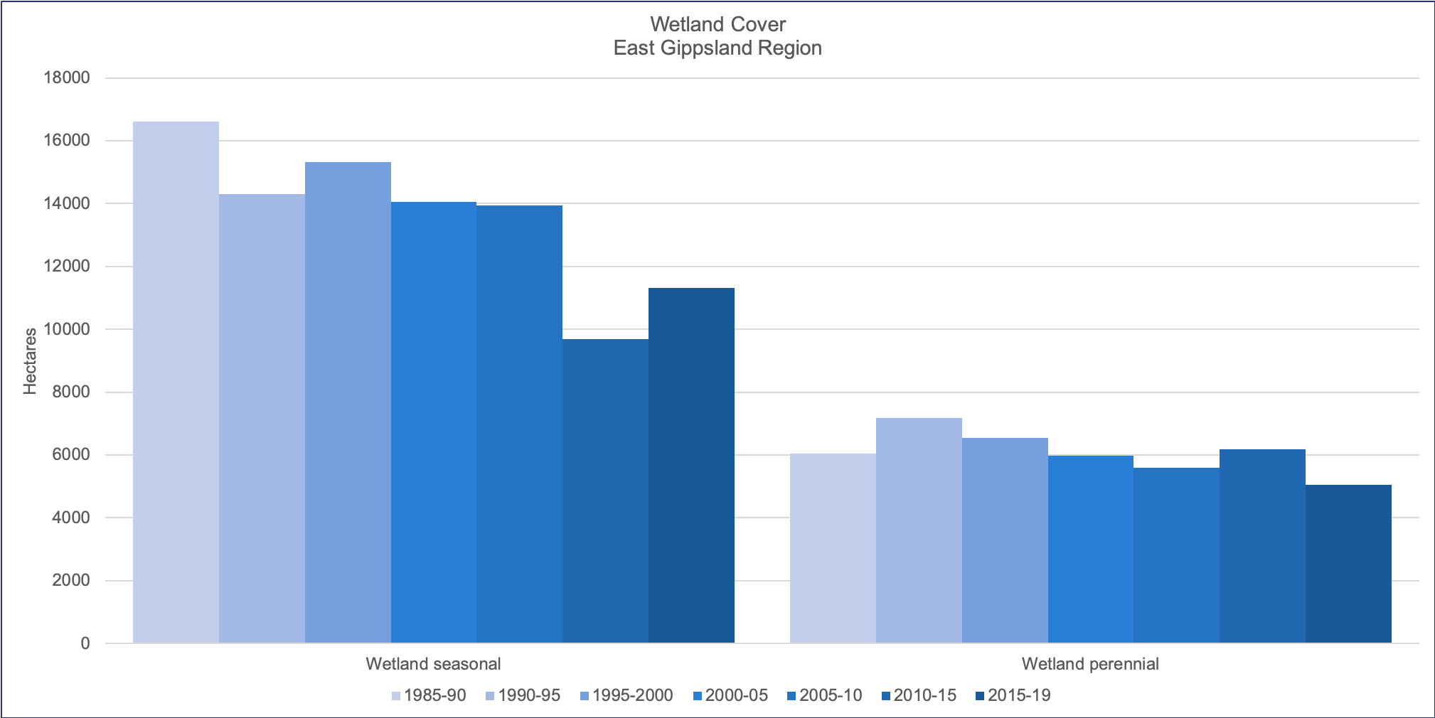
Wetland extent has been mapped from the herbaceous cover of native plant species (Figure 2). This indicates a decline in seasonal freshwater wetland vegetation extent in the region over the past 35 years. The area of open water, however, has largely remained stable over the same time period (Victorian Land Cover Time Series: DELWP).
Figure 2: Change in extent of wetland vegetation cover (hectares) in the East Gippsland Region.
Source: Victorian Land Cover Time Series (DELWP).
Rivers
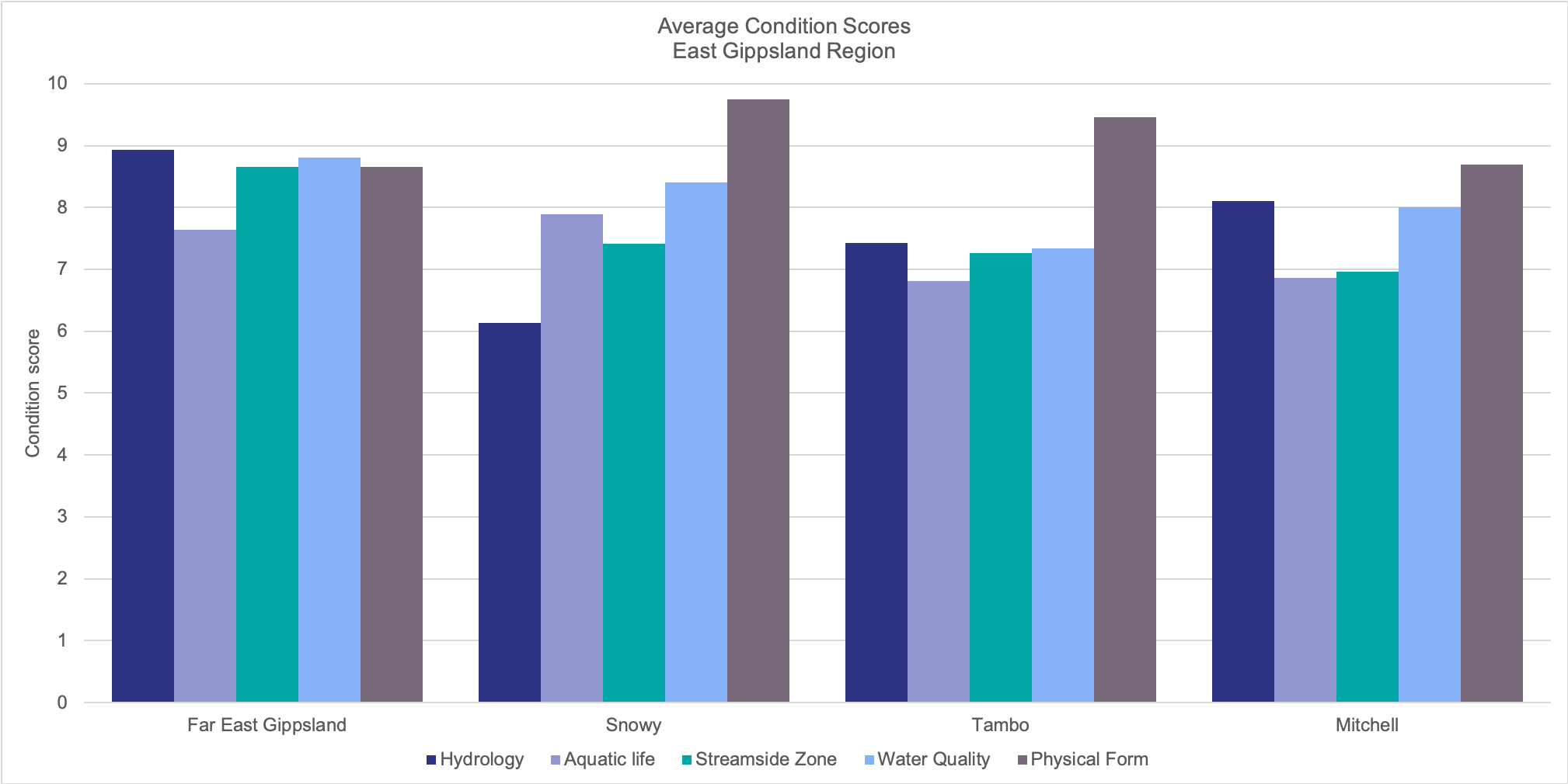
Condition of rivers in East Gippsland was assessed as part of the state-wide 2010 Index of Stream Condition. The majority of rivers in the region were in excellent or good condition, ranging from over 95% of river length in far east Gippsland to just under 70% of rivers in the Snowy and Tambo Basins (Figure 3). The rivers of Far East Gippsland scored highly across most of the sub-indices, while in the remaining river basins, not all sub-components fared the same. In the Snowy Basin, altered hydrology, largely due to upstream extractions has reduced the condition of the river, although water quality remains in largely good condition. In the Tambo, average water quality was lower, and in the Mitchell, there were lower average scores for physical form (Figure 4).
Figure 3: River length (%) in condition categories for the river basins in East Gippsland.
Source: the Third Index of Stream Condition (DEPI 2013).
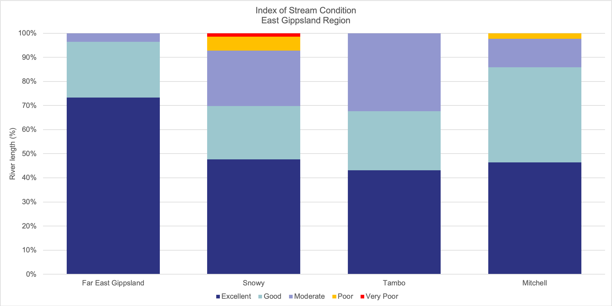
Figure 4: Average condition scores (out of 10) for each of the sub-components of the Index of Stream Condition for the river basins in East Gippsland.
Source: the Third Index of Stream Condition (DEPI 2013).
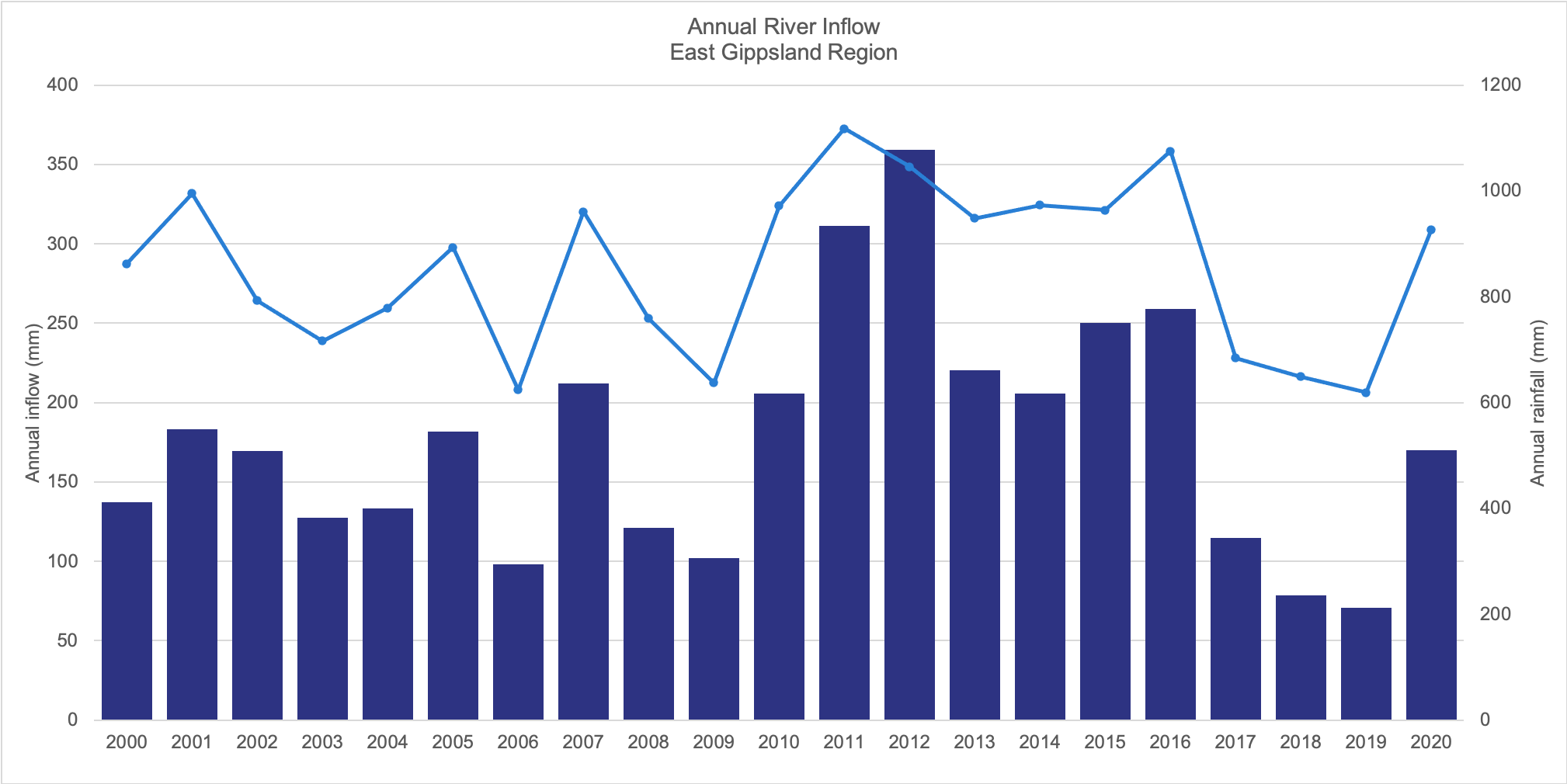
Average river inflows in East Gippsland vary considerably from year to year. In the last two decades, this has ranged from a high of over 350 millimetres in 2012 to just 71 millimetres in 2019 (Figure 5). This is, however, tightly coupled to patterns in rainfall across the region.
Figure 5: Annual river inflow (mm) and rainfall (mm) in the East Gippsland Region over time.
Source: Australia’s Environment Explorer (ANU-WALD).
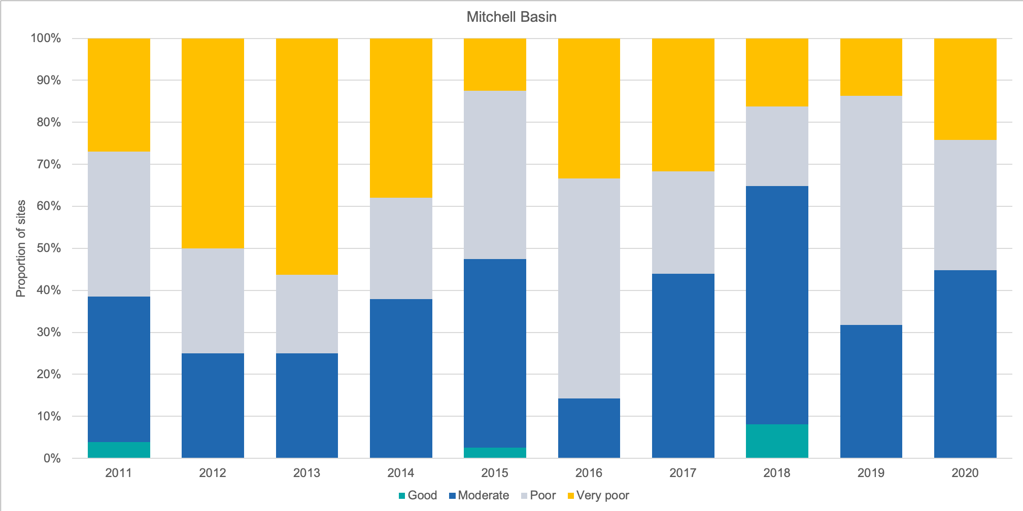
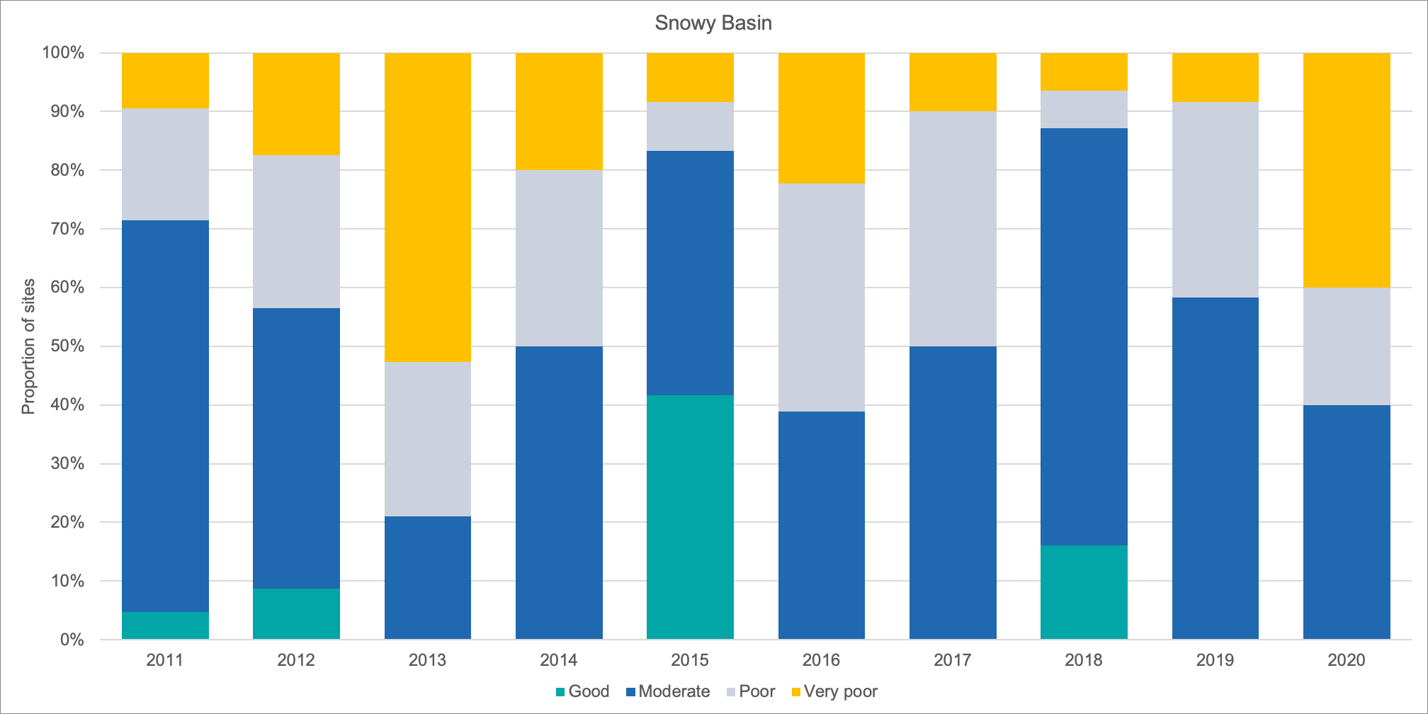
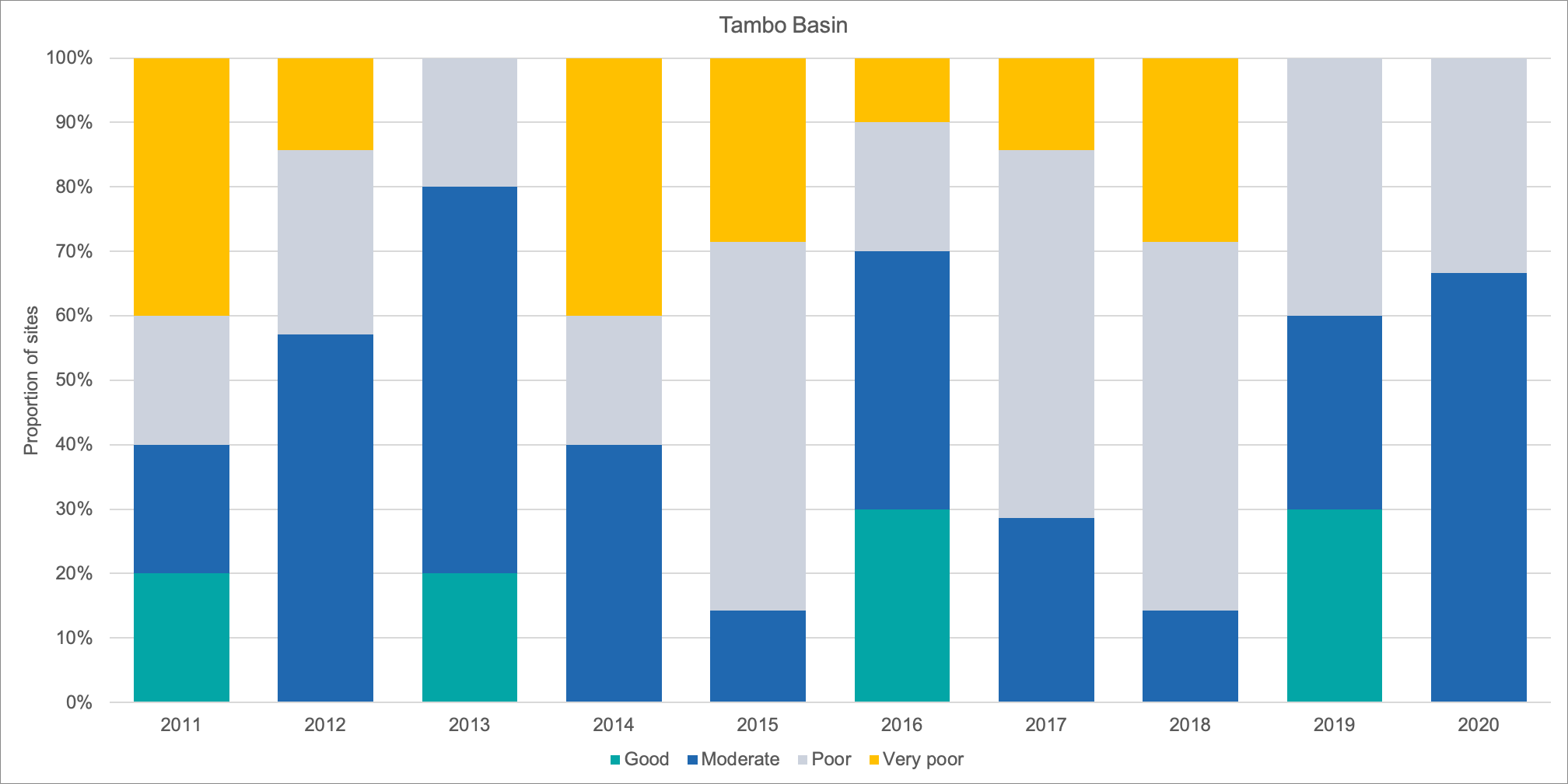
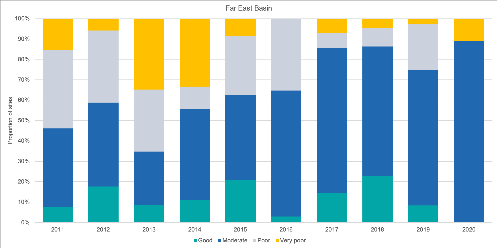
Trends in riparian condition from 2011 to present illustrate the effects of riparian restoration works in East Gippsland (Figure 6). In the Far East of the catchment, in particular there have been consistent improvements in riparian condition over the past decade. While the pattern is less clear in the other three river basins, there is evidence that fencing, stock management and removal of willows and other weeds is having a positive effect on river health.
Figure 6: Proportion of riparian sites assessed in condition classes across East Gippsland from 2011 to 2020.
Mitchell Basin
Snowy Basin
Tambo Basin
Far East Basin
Groundwater
Changes in groundwater level can be tracked through the State Bore Monitoring Network. While the majority of the bores in East Gippsland indicate stable water levels, there are areas on the Red Gum Plains, to the west of Bairnsdale where water level trends are declining (e.g. Bore number 77947; Table 4). This reflects the relatively higher levels of groundwater extraction for consumptive use in this region.
Table 4: Groundwater level (m) monthly averages and trends in active SOBN bores in the East Gippsland Region.
Water – Regional Outcome Targets
These regional outcomes relate to the water theme within the RCS. They set out the long term (to 2040) and medium term (to 2027) outcomes as they relate to the region’s water assets. The outcomes include those aligned with the statewide outcomes framework (in italics) as well regionally specific outcomes developed in collaboration with RCS partners.
The RCS outcomes framework can be found here, and more detailed outcomes addressing each theme of the RCS and linked closely to each of the local areas can be found here.
Medium-term
Outcomes (2027)
Extent of permanent wetlands will be maintained at or above the average recorded for 2005-2019 (5600 ha).
An additional 1600 ha of riparian land will be protected or improved along priority waterways.
Alpine peatlands currently in good condition will remain in good condition, through protection from the impacts of pest plants and animals and physical impacts to hydrology at these sites.
Extent, structure, and diversity of riparian vegetation is improved along priority waterways, through:
- maintaining waterways free of willows
- excluding livestock grazing on 75% of waterway frontages in cleared sections
- completing surveillance for new and emerging weeds in remote tributaries
Water regimes in MacLeod Morass are managed to maintain freshwater conditions in the upper Morass as indicated by annual average EC of < 500 uS/cm.
Long-term
Outcomes (2040)
85% of alpine peatlands within East Gippsland are in good condition.
Macleod Morass is maintained as a freshwater wetland.
The condition of riparian vegetation and connectivity in priority wetlands and waterways is improved, providing habitat for native animals, and improving resistance and resilience of waterways, and reducing risk of instability.
Links between groundwater levels and priority Groundwater Dependant Ecosystems across East Gippsland are understood.
| Management Direction | Current | Future Opportunity | Partners involved |
|---|---|---|---|
| Continue to implement the East Gippsland Waterway Strategy (including a review during 2022 and renewal of the strategy by 2024). | EGCMA, DELWP, Parks Victoria, GLaWAC | ||
| Continue to implement the strategies of the Gippsland Lakes Ramsar Site Management Plan (including an update to the plan in 2023). | EGCMA, GLaWAC, DELWP, Parks Victoria, WGCMA, DAWE, EGSC, WSC, Greening Australia, TfN, Birdlife Australia, Agriculture Victoria | ||
| Implement a strategic and integrated program to control willows and other invasive tree weeds along waterways, focussing on high value stream and areas recovering from fire impact. | EGCMA, DELWP, Parks Victoria, GLaWAC | ||
| Develop and implement the recommendations of the Snowy River Flows Study. | EGCMA, DELWP | ||
| Seek to progress and implement on ground works for the partial removal of the Nicholson Dam wall. | EGCMA, EGW, DELWP | ||
| Support activities for improving integrated water management as specified in the East Gippsland Integrated Water Management Strategic Directions Statement. | EGCMA, EGSC, EGW, DELWP | ||
| Support the development of the Central and Gippsland Sustainable Water Strategy, including supporting GLaWAC in the use and delivery of cultural flows on the Mitchell River, and permits and approvals for the partial removal of the Nicholson Dam wall. | EGCMA, DELWP, GLaWAC | ||
| Support the implementation of the Victorian Alpine Peatlands Spatial Action Plan | EGCMA, Parks Victoria, GLaWAC, DELWP | ||
| Target investment to specific peatlands where recovery is slower or threats have not been reduced enough to allow recovery. | EGCMA, Parks Victoria, GLaWAC, DELWP | ||
| Work with landholders to construct fencing along waterways and keep stock out | EGCMA, DELWP, Private landholders |