Overview
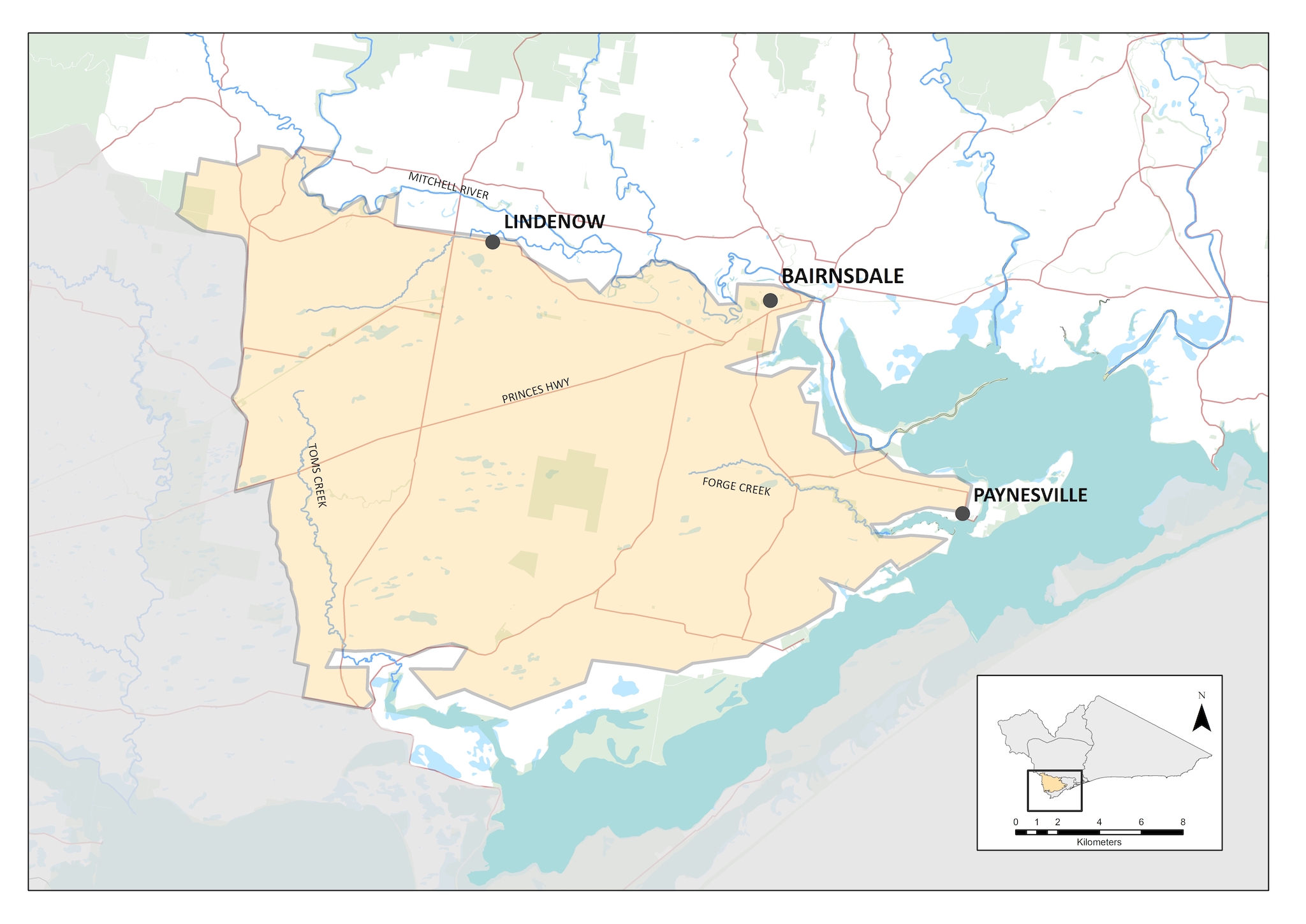
The Gippsland Red Gum Plains extend from near Traralgon and the Latrobe Valley in the west, to Bairnsdale in the east (refer to map). The northern boundary of the plains is characterised by the heavier vegetated foothills of the Victorian Alps. While the plains have been mostly cleared of native vegetation to support agriculture production (mainly dryland sheep and cattle), remnants of EPBC listed Red Gum Grassy Woodland and Associated Grassland and Seasonal Herbaceous Wetlands (Freshwater) of the Temperate Lowland Plains communities do remain, alongside other threatened flora species. As a result, in the recent past, the eastern Red Gum Plains have been an important area for permanent protection on private land..
Only a portion of the Red Gum Plains lies within the East Gippsland CMA region. This equates largely to the areas north of Lake Victoria in the Gippsland Lakes. While East Gippsland CMA will continue to work collaboratively with West Gippsland CMA to manage the Red Gum Plains, this local area paper is focussed on the portion of the local area that is within the East Gippsland CMA region.
Through having been extensively cleared for agriculture, the remnant native vegetation across the plain is scarce and highly fragmented. This remnant vegetation includes two communities that are considered to be critically endangered under the Environment Protection and Biodiversity Conservation Act: Gippsland Red Gum Grassy Woodland and Associated Native Grassland, and Seasonal Herbaceous Wetlands (Freshwater) of the Temperate Lowland Plains. There are also many endangered flora and fauna species found on the plain.
Available data indicate that the Red Gum Plains is in moderate condition (Table 1).
Table 1: Condition and trend of the Red Gum Plains
The following high or very high threats to dry forest and woodland of the Red Gum Plains Local Area have been identified through the Conservation Action Plan for the Gippsland Plains and Strzelecki Ranges Parks Landscape, regional Biodiversity Response Planning process (Red Gum Plains Focus Landscape) and stakeholder workshops.
Habitat fragmentation
Infrastructure and development, such as construction of roads, fuel breaks, and other structures, can reduce connectivity between habitat and populations across the local landscape.
Natural resource extraction
Legal and illegal natural resource extraction can destroy habitat (e.g. grazing, timber harvesting, track creation) or directly affect species populations (e.g. hunting, fishing).
Weed invasion
Weeds displace native species, alter vegetation structure and impact fire regimes. Over abundant native species displace existing flora.
Predation
Declines in populations and abundance of native species due to fox and cat predation. Introduced predators can act as disease and weed vectors.
Grazing
Threats to vegetation communities including threatened species from introduced grazers in particular rabbits and deer.
Altered flow regimes
Changes to natural flow regimes impacting upon wetlands and flow connectivity.
Land clearing
Incremental land clearing, edge effects and lack of secure tenure, particularly from grassland and grassy woodland remnants and linear reserves.
Vision
The resilience of natural assets, agriculture and communities in the Red Gum Plains Local Area are increased and ecosystem services are maintained in the face of climate change and other stressors.
Outcomes
By 2040, the long-term objectives for the Red Gum Plains are to:
- protect and enhance the condition of the high and medium quality threatened vegetation communities (Gippsland Red Gum Grassy Woodland and Associated Native Grassland and Seasonal Herbaceous Wetlands (Freshwater) of the Temperate Lowland Plains.
- promote sustainable land management practices, particularly relating to soil and groundcover management, that support higher productivity and protection of the environment
- maintain and improve the condition of significant waterways on the Red Gum Plains
- promote awareness of, and participation by, communities and land managers in the management and protection of the vegetation communities on the Red Gum Plains; and recognise, develop and utilise Traditional Owner knowledge of the cultural landscape.
This will be achieved by focussing on the following themes:
- Biodiversity – protecting remnant native vegetation
- Water – protecting waterway health; including Seasonal Herbaceous Wetlands
- Land – increased resilience and production in agricultural land
- Community – supporting community and landholder participation.
Water – protecting waterway health
Current State
(2021)
Waterways such as Forge Creek, Toms Creek and wetlands in this local area are subject to pressures from agricultural activities including stock grazing, nutrient and sediment inflows and past land clearing.
Medium-term
Outcomes (2027)
Extent, structure, and diversity of vegetation on riparian corridors is improved along Forge and Toms creeks.
Extent, structure, and diversity of vegetation on Gippsland Plains priority wetlands is improved.
Long-term
Outcomes (2040)
The condition of riparian vegetation along Forge Creek, Toms Creek and priority wetlands is improved, providing habitat native animals, and improving resistance and resilience of waterways, reducing risk of instability.
Biodiversity – protecting remnant native vegetation
Current State
(2021)
High quality remnants, particularly of Gippsland Red Gum Grassy Woodlands, are at risk due to threats from invasive weeds, rabbits, livestock grazing, and altered fire and hydrological regimes. There are also many patches of other medium quality remnants with low levels of protection and connectivity.
Medium-term
Outcomes (2027)
Maintain, and where possible improve, the condition of Gippsland Plains Grassy woodland, increase extent by 30%.
Increase the area of native vegetation under permanent protection.
There will be no reduction in known threatened plant species populations.
Bird numbers and species diversity will remain stable at 2020 levels.
Long-term
Outcomes (2040)
The Gippsland Red Gum Plains will have improved ecological function. All significant areas of remnant native vegetation will have basic protections in place and will be better connected to each other across the landscape via strategic plantings.
Land – protecting agricultural land and soil health
Current State
(2021)
Emerging focus on sustainable practices, particularly relating to soil and groundcover management. The focus is shifting from recovery following drought to increasing resilience to climate change and other stressors.
Medium-term
Outcomes (2027)
Continue to work with landholders to improve farm management practices
Effective management of groundcover to conserve soils for the benefit of both agriculture and the natural environment.
Landholders will use systems and techniques to deliver long term outcomes for both farming and the environment, making the whole system more resilient to on-going threats (e.g. invasive weeds, pest animals) and to climate change.
Long-term
Outcomes (2040)
Over 750 properties with active sustainable land management practices in place relating to soil and groundcover management.
Community – supporting community and landholder participation
Current State
(2021)
Emerging awareness of local native vegetation and participation in protection programs. There is also growing interest in alternative farming practices aimed at improved soil and land management (e.g. Landcare, Regeneration Ag Alliance, Soils for Life, Soil Ambassador).
Medium-term
Outcomes (2027)
Community actively involved in agricultural and Landcare groups.
Community invited to participate in citizen science programs, such as bird, frog, turtle and water quality monitoring.
Long-term
Outcomes (2040)
High awareness of local native vegetation and active participation in protection programs with increased numbers of groups and landholders actively involved and measured levels of awareness improved.
With respect to the delivery of actions outlined in each of the Local Areas covered by this RCS, there are four phases in the implementation framework:
- Target setting – A vision is set for each local area, including outcomes, aiming for the healthiest environment tailored to community and Traditional Owner aspirations and regional characteristics. Actions are developed in collaboration with partner agencies, targeting threats to the Local Area.
- Taking action – Land managers and community work intensively to maintain and improve our natural environments. Examples of work undertaken during this phase include pest plant and animal control, revegetation, and hosting engagement events. This phase is working together to achieve results on the ground.
- Recovery and growth – Once the delivery of on ground works is complete, the local area (and the life within it) will take some time to recover and establish. In some cases, environmental works will cause a minor decline before the environment can find its balance and improve in condition. This phase provides for on ground works to be delivered at a level for the environment to establish into a stronger, more resilient, and healthier Local Area.
- Target achieved – The Local Area is resilient, providing community values and is largely naturally sustained. Threats to the local area are now reduced (along with the costs to fix them). The environment is stronger, more resistant, and resilient to threats. The local area will need minimal maintenance, although ongoing monitoring may be required, and the outcomes have been achieved
These phases describe the current status and trajectory of the local area. Different places across a single Local Area may be in different phases of the implementation framework. The Red Gum Plains are currently in phase 2, Taking Action. This reflects the substantial planning and past works supported by investment from both the Victorian and Australian Governments. These works have focussed on addressing threats from grazing pressure, weeds, feral animals and clearing; and has included fencing, permanent protection through private land covenants, pest plant and animal control, ecological burning and thinning, revegetation, landholder agreements and cultural survey and mapping. With stakeholders and community working together, some of the more degraded areas are beginning to show signs of recovery.