Overview
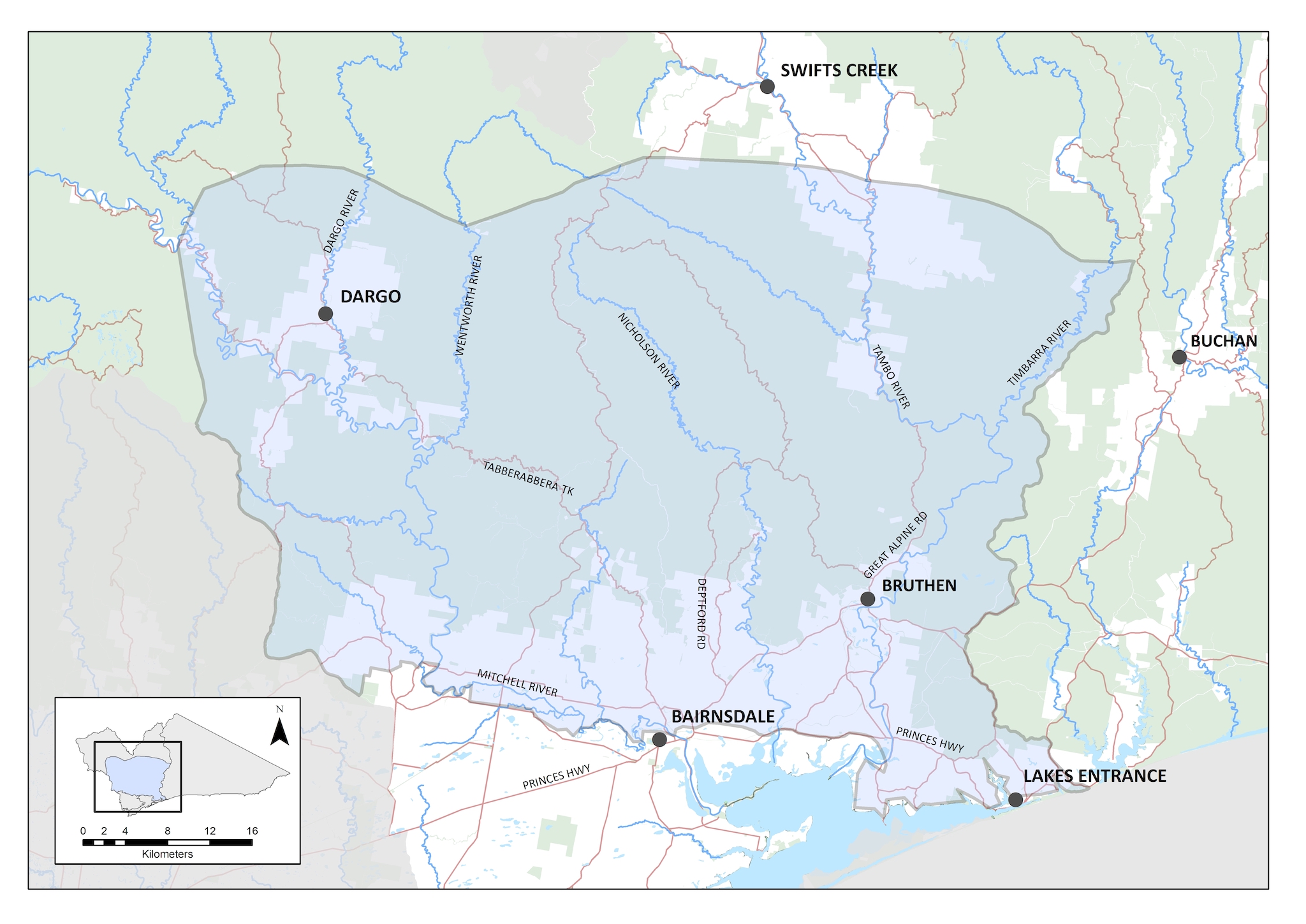
The Forested Foothills Local Area extends from Dargo to Bairnsdale and across to Bruthen (refer to map). The northern boundary of the plains is characterised by the peaks of the Victorian Alps, through to the top of the Red Gum Plains in the south.
The Forested Foothills are strongly associated with the Gippsland Lakes priority landscape area comprising much of the eastern river catchments that flow into the lakes, including the Mitchell, Tambo and Nicholson rivers.
The area primarily comprises a patched mosaic of cleared and vegetated land. The native vegetation is dominated by lowland eucalypt forests of stringybark and silver top ash. The grazing land is made up of small to medium holdings that support sheep and cattle, and some forestry.
The foothills support a diverse range of flora and fauna species, including threatened species such as the Southern Greater Glider, Lace Monitor and Sooty Owl.
Available data indicate that the Forested Foothills is in moderate condition (Table 1).
Table 1: Condition and trend of the Forested Foothills
The following high or very high threats to this local area have been identified through regional Biodiversity Response Planning (Tambo Foothills, Mitchell Foothills) and stakeholder workshops:
Natural resource extraction
Legal and illegal natural resource extraction can destroy habitat (e.g. grazing, timber harvesting, track creation, illegal firewood collection) or directly affect species populations (e.g. hunting, fishing).
Weed invasion
Weeds displace native species, alter vegetation structure and impact fire regimes. Over abundant native species displace existing flora
Predation
Declines in populations and abundance of native species due to fox and cat predation. Introduced predators can act as disease and weed vectors
Grazing
Threats to vegetation communities including threatened species from introduced grazers in particular rabbits and deer
Fire
Increased fire frequency and intensity impacting terrestrial and aquatic habitats.
Vision
The resilience of natural assets, agriculture and communities in Forested Foothills Local Area are increased and ecosystem services are maintained in the face of climate change and other stressors.
Outcomes
By 2040, the long-term objectives for the Forested Foothills are to:
- protect and enhance the condition of unique vegetation communities that support native animals and cultural values, in areas including the Mitchell River National Park, Colquhoun and Mount Elizabeth State Forests, and rainforest gullies
- reduce threats and improve habitat to maintain population of key animal species, including owls, gliders and glossy black-cockatoos
- integrated fire management across the Forested Foothills, communities and partners agencies working together to manage the landscape to protect communities, built assets and the environment
- promote sustainable land management practices, particularly relating to soil and groundcover management, that support higher productivity and protection of the environment
- maintain and improve the condition of significant waterways and tributaries of the Mitchell, Nicholson and Tambo rivers
- promote awareness of, and participation by, communities and land managers in the management of fire, land health, vegetation protection and improving waterway health; also recognise, develop and utilise Traditional Owner knowledge of the cultural landscape.
This will be achieved by focussing on the following themes:
- Biodiversity – protecting unique vegetation communities
- Water – protecting waterway health in the Mitchell, Nicholson and Tambo catchments
- Land – increased resilience and production in agricultural land
- Community – supporting community and landholder participation, and embracing Traditional Owner knowledge.
Water – improving the condition of the Mitchell, Nicholson and Tambo Rivers
Current State
(2021)
Mitchell, Nicholson and Tambo rivers are free of willows.
Some sections of waterway have continuous native vegetation riparian corridors with stock excluded.
Medium-term
Outcomes (2027)
95% of priority waterways are maintained as free of willows, and ongoing surveillance is undertaken for new and emerging riparian weeds in remote tributaries.
75% of priority reaches in the Nicholson, Tambo and Mitchell Rivers have continuous native vegetation riparian corridors with stock excluded
Long-term
Outcomes (2040)
Rivers and tributaries are maintained as free of willows and no new and emerging weeds are established.
All reaches of the Nicholson, Tambo and Mitchell Rivers have continuous native vegetation riparian corridors with stock excluded
Biodiversity – working with land managers across the region to address pest plants and animals
Current State
(2021)
Pest plant and animals threaten unique vegetation communities.
Pest animals such as deer, together with transforming weeds impact on native vegetation.
Following landscape scale bushfires, these are key priorities moving forward.
Medium-term
Outcomes (2027)
Impacts are reduced on unique vegetation communities and native animals are protected through ongoing integrated through weed control, large herbivore control, and habitat improvement.
Long-term
Outcomes (2040)
Unique vegetation communities are maintained.
Maintenance and targeted improvement of the condition, security, diversity and integrity of natural ecosystems and the status of threatened species.
Fire regimes are suitably managed.
Land – protecting agricultural land, productivity and soil health
Current State
(2021)
Emerging focus on sustainable practices, particularly relating to soil and groundcover management. The focus is shifting from recovery following drought to increasing resilience to climate change and other stressors.
Medium-term
Outcomes (2027)
Continue to work with landholders to improve farm management practices.
Effective management of groundcover to conserve soils for the benefit of both agriculture and the natural environment.
Landholders will use systems and techniques to deliver long term outcomes for both farming and the environment, making the whole system more resilient to on-going threats (e.g. invasive weeds, pest animals) and to climate change.
Long-term
Outcomes (2040)
Targeted improvement of the productive values and stability of the Dargo Mountain Basin and Tambo Valley agricultural land and soils.
Community – working together on land and waterway management
Current State
(2021)
Community is involved in discussions and decisions with land managers and partner agencies in the management of fire, land health, vegetation protection and improving waterway health.
Medium-term
Outcomes (2027)
Community and Landcare Groups are collaboratively working with land managers and other partner agencies to be involved in fire and environmental management.
Long-term
Outcomes (2040)
Community, partner agencies and land managers working seamlessly together to achieve environmental outcomes.
Landcare are integral to the collaborative approach with land managers and partner agencies.
With respect to the delivery of actions outlined in each of the Local Areas covered by this RCS, there are four phases in the implementation framework:
- Target setting – A vision is set for each local area, including outcomes, aiming for the healthiest environment tailored to community and Traditional Owner aspirations and regional characteristics. Actions are developed in collaboration with partner agencies, targeting threats to the Local Area.
- Taking action – Land managers and community work intensively to maintain and improve our natural environments. Examples of work undertaken during this phase include pest plant and animal control, revegetation, and hosting engagement events. This phase is working together to achieve results on the ground.
- Recovery and growth – Once the delivery of on ground works is complete, the local area (and the life within it) will take some time to recover and establish. In some cases, environmental works will cause a minor decline before the environment can find its balance and improve in condition. This phase provides for on ground works to be delivered at a level for the environment to establish into a stronger, more resilient, and healthier Local Area.
- Target achieved – The Local Area is resilient, providing community values and is largely naturally sustained. Threats to the local area are now reduced (along with the costs to fix them). The environment is stronger, more resistant, and resilient to threats. The local area will need minimal maintenance, although ongoing monitoring may be required, and the outcomes have been achieved
These phases describe the current status and trajectory of the local area. Different places across a single Local Area may be in different phases of the implementation framework.