Overview
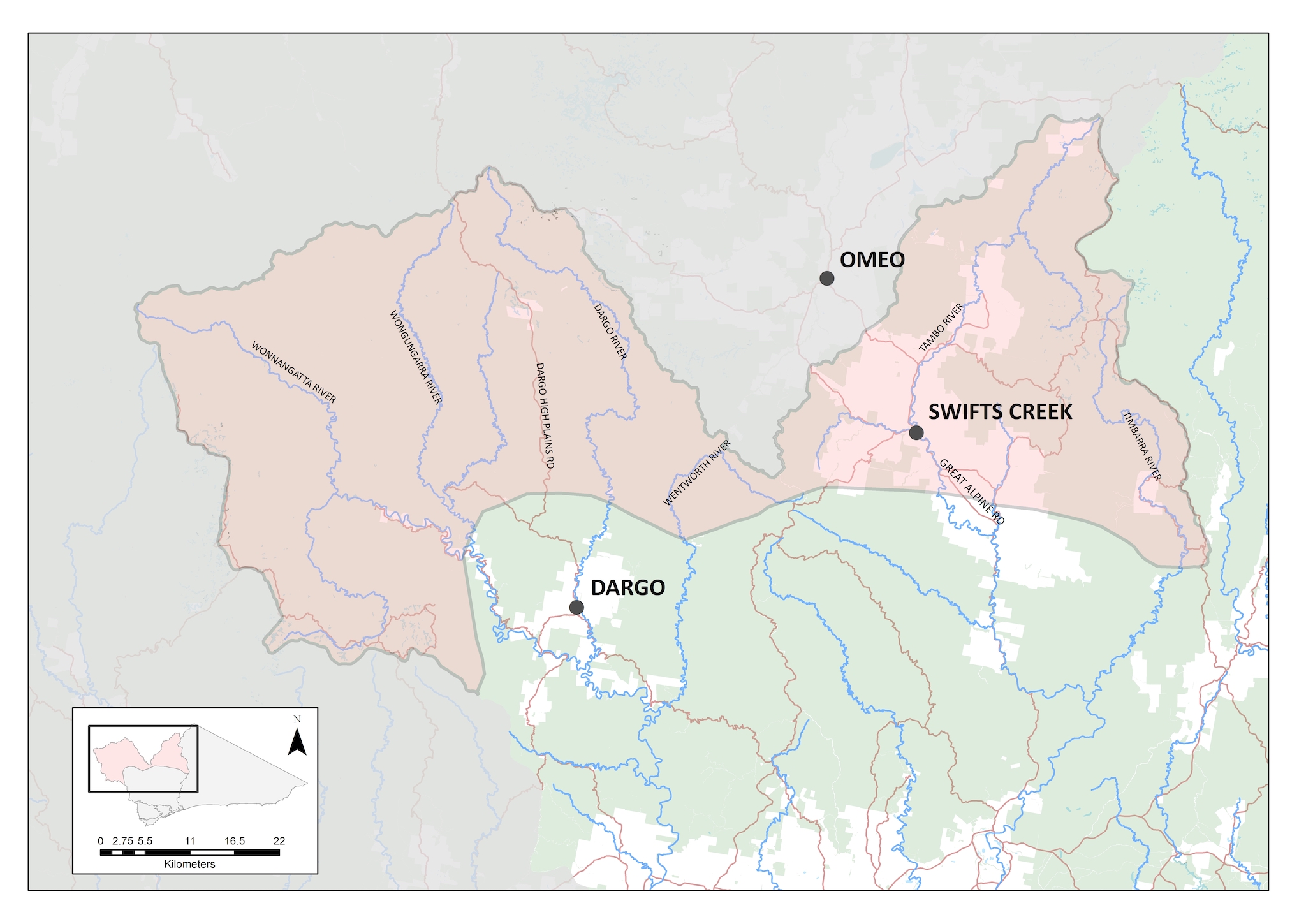
The Alpine Peaks local area within the East Gippsland Catchment Management Region comprises the upper catchments of the Mitchell, Nicholson and Tambo rivers. It is bounded to the north by the Great Dividing Range and to the south by the forested foothills. It contains a portion of the Alpine National Park, which covers over a third of this local area.
The area features two important and rare ecological communities, White Box-Yellow Box-Blakely’s Red Gum Grassy Woodland and Derived Native Grassland (or Box-Gum Grassy Woodlands), and Alpine Sphagnum Bogs and Associated Fens (or Alpine Peatlands).
There are only 4,480 hectares of Alpine Peatland, all found in high elevations of the Victorian Alps. The peatlands are permanently wet sites in high rainfall alpine, sub-alpine and montane areas of the state. The community is listed as endangered under the Commonwealth Environment Protection Biodiversity Conservation Act due to:
- its small geographic distribution coupled with demonstrable threats
- the continued decline of functionally important species
- the severe reduction in community integrity across its range.
Box-Gum Grassy Woodlands provide important habitat for a large number of plants and animals, including threatened species. These woodland were formerly widespread however now less than 5% remains in good condition across its range and much of this occurs in small isolated patches.
Areas of land used for agriculture, largely devoid of trees, sit within the large areas of native forest and woodland. They are located primarily in river valleys and are mostly used for agricultural production. They include the Wonnangatta Valley in the Mitchell catchment, and Ensay and Swifts Creek in the Tambo Valley.
Available data indicates that the Alpine Peaks Local Area is in very good condition (Table 1). However, in 2019-20, bushfires affected over a third of this local area, burning a large proportion of the native vegetation and killing or displacing large numbers of animals. The full extent of the impact and recovery from this event is not yet well understood.
Table 1: Condition and trend of Alpine Peaks Local Area
The high proportion of public land and retention of much of the native vegetation and habitats of the region, coupled with a relatively sparse population, means that the Alpine Peaks is subject to lower levels of threat from changed land use than elsewhere in Victoria and the East Gippsland Region. Over much of the local area threats to biodiversity arise from:
Climate change
Increase in temperatures coupled with decreased rainfall have led to an increase in the risk of severe bushfire events. This occurred in 2019-20, where over 1 million hectares, (56%) of the East Gippsland region was burnt.
Pest plants and animals
Despite much of East Gippsland retaining native vegetation cover, there are still areas of priority weeds and a number of significant pest animal threats to biodiversity. Alpine peatlands and upland pristine streams are at extreme risk from deer and feral horses, with hard hooves causing significant and often irrevocable damage to fragile peat communities. Willows and non-woody weeds also pose a threat to these communities, with invasion of willows following bushfire of particular concern. Also, wild dogs and agricultural weeds continue to impact of farming enterprises.
Vision
The ecological character, extent and condition of the Alps Natural Ecosystem and associated environments is maintained including alpine grassland and heathland mosaic, White Box Woodlands and wetlands. Communities are resilient, connected and value the unique alpine landscapes and farming districts.
Outcomes
By 2040, the long-term objectives for the Alpine Peaks are:
- Ensure the total extent of the Alpine Peatlands is maintained, and that those peatlands that are currently in good condition are protected, and any peatlands that are in medium or poor condition are restored to good condition by 2040.
- Populations of threatened species and ecological communities are maintained.
- Improvement of the productive values and stability of the Dargo Mountain Basin and Tambo Valley agricultural land and soils in priority areas.
- Public spaces, visitor facilities and recreational opportunities are discoverable, in good condition and suitable for the needs of users.
- Landcare are integral to the collaborative approach with land managers and partner agencies.
This will be achieved by focussing on the following themes:
- Water – improving the condition of the Alpine Peatlands in the Wonnangatta-Moroka and Dargo High Plans areas
- Biodiversity – working with land managers across the region to address established and emerging pest plants and animals
- Land – reducing erosion following bushfires and continue to control pest plants and animals
- Community – Landcare encouraging recreational activities and opportunities through working with land managers to maintain and improve visitor facilities.
Water – improving the condition of the Alpine Peatlands in the Wonnangatta-Moroka and Dargo High Plains areas
Current State
(2021)
Most of the peatlands in the Wonnangatta-Moroka area are in good condition but some have been affected by weeds, particularly willows, vehicle and walking tracks (that have affected water flows into and out of peatlands) and damage by pest animals such as deer.
Medium-term
Outcomes (2027)
Alpine peatlands currently in good condition will remain in good condition, through protection from the impacts of pest plants and animals and physical impacts to hydrology at these sites.
Long-term
Outcomes (2040)
75% (615 hectares) of peatlands in the Wonnangatta-Moroka areas will be maintained in their current good condition.
The remaining 25% (205 hectares) of peatlands are improved from medium or poor condition to good condition.
Biodiversity – working with land managers across the region to address established and emerging pest plants and animals
Current State
(2021)
Pest plant and animals threaten Alpine Peatlands and terrestrial habitats in the region, including white box woodlands. Pest animals such as horses, deer, and pigs, together with transforming weeds have been identified as a significant threat to alpine ecosystems. Following landscape scale bushfires, this is a key priority moving forward.
Medium-term
Outcomes (2027)
Impacts are reduced on threatened vegetation communities and individual animals through ongoing integrated large herbivore control (deer, horses, pigs).
Threatened animals protected through ongoing integrated predator (fox and cat) control in priority refuge habitats.
Long-term
Outcomes (2040)
Populations of threatened species and ecological communities are maintained.
Maintenance and targeted improvement of the condition, security, diversity and integrity of natural ecosystems and the status of threatened species and communities.
Land – reducing erosion following bushfires
Current State
(2021)
The 2019/20 bushfires impacted a large proportion of the Alpine Peaks local area. While much of the land affected was public and supported natural values, there were impacts to productive agricultural lands as well.
Medium-term
Outcomes (2027)
Best practice soil management, including maintaining appropriate ground cover is implemented at 60 % of priority sites across the agricultural landscape.
Long-term
Outcomes (2040)
Targeted improvement of the productive values and stability of the Dargo Mountain Basin and Tambo Valley agricultural land and soils.
Community – working together to improve public spaces and recreational and visitor facilities
Current State
(2021)
Landcare community is working on several projects to improve visitor facilities and achieve beneficial environmental outcomes.
Medium-term
Outcomes (2027)
Landcare groups are collaboratively working with land managers and other partner agencies to improve public spaces, visitor facilities and recreational opportunities.
Long-term
Outcomes (2040)
Public spaces, visitor facilities and recreational opportunities are discoverable, in good condition and suitable for the needs of users.
Landcare are integral to the collaborative approach with land managers and partner agencies.
With respect to the delivery of actions outlined in each of the Local Areas covered by this RCS, there are four phases in the implementation framework:
- Target setting – A vision is set for each local area, including outcomes, aiming for the healthiest environment tailored to community and Traditional Owner aspirations and regional characteristics. Actions are developed in collaboration with partner agencies, targeting threats to the Local Area.
- Taking action – Land managers and community work intensively to maintain and improve our natural environments. Examples of work undertaken during this phase include pest plant and animal control, revegetation, and hosting engagement events. This phase is working together to achieve results on the ground.
- Recovery and growth – Once the delivery of on ground works is complete, the local area (and the life within it) will take some time to recover and establish. In some cases, environmental works will cause a minor decline before the environment can find its balance and improve in condition. This phase provides for on ground works to be delivered at a level for the environment to establish into a stronger, more resilient, and healthier Local Area.
- Target achieved – The Local Area is resilient, providing community values and is largely naturally sustained. Threats to the local area are now reduced (along with the costs to fix them). The environment is stronger, more resistant, and resilient to threats. The local area will need minimal maintenance, although ongoing monitoring may be required, and the outcomes have been achieved
These phases describe the current status and trajectory of the local area. Different places across a single Local Area may be in different phases of the implementation framework. Protection works have been underway for some time within the Alpine Peaks Local Area, and the area is largely in the Taking Action phase, with many areas now recovering, particularly in the Eastern Alps. The overall patterns of condition change illustrated here are based on the expectation that protection and restoration works will continue to show a general increase in ecological condition over time.